Cargando...
Recursos educativos
-
Nivel educativo
-
Competencias
-
Tipología
-
Idioma
-
Tipo de medio
-
Tipo de actividad
-
Destinatarios
-
Tipo de audiencia
-
Creador
Lo más buscado
- Descargar ejercicios de geometría
- Química elemental
- redacción
- Actividades con numeros enteros para imprimir
- Arte español para primero
- Ejercicios de repaso y refuerzo
- Francés-Lengua extranjera
- Distibución de la población
- Actividades educativas para niños en tercero
- Rinoceronte
- Comunidades autónomas
- Imprimir material primero
- Experimentos cuarto
- Actividades didacticas en P3
- Carga eléctrica para tercero
-

Measuring precipitation
EduBook Organización
- 1733 visitas
A rain gauge measures the quantity of rain that falls in a place over a certain period of time. A rain gauge has a tank with a scale on its side. It has a funnel at the top. The water collected is…
-

What Does the Research Tell Us About Teacher Leadership?
jose lucio Docente
- 2 lo usan
- 1317 visitas
MethodologyThe authors of this meta-analysis investigated the concept and practice of teacher leadership in the research literature from the past two decades. The literature reviewed includes numerous…
-

Analyse. A metropolitan area
EduBook Organización
- 1657 visitas
This image is from a topographical map of London's metropolitan area, to a scale of 1:50000. Find the location of the following places: Densely populated metropolitan areas. Industrial estates.…
-

Find out more
EduBook Organización
- 1649 visitas
Analogue thermometers work due to the changes in volume in their column of liquid. Thermometers have a glass tube with a liquid that dilates when it heats up and contracts when it cools down. The…
-
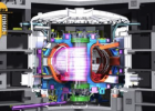
ITER - the way to new energy
V&V Books Vicens Vives Organización
- 170 visitas
ITER is the world's largest fusion experiment. Thirty-five nations are collaborating to build and operate the ITER Tokamak, the most complex machine ever designed, to prove that fusion is a viable…
-

The Population of Spain
EduBook Organización
- 5272 visitas
Spain is not densely populated compared to other European countries. However, in the 20th century the population began to grow. The major changes in Spain's population in recent decades have been…
-

9. Self-evaluation - The representation of the Earth: maps
EduBook Organización
- 4578 visitas
Decide which subject the following sentences refer to: In order to study precipitation and temperature, we use climate maps. The Earth's imaginary lines form a grid over the planet's surface.…
-

Discover…Types of maps
EduBook Organización
- 4490 visitas
In general, geographers work with two types of maps: topographic and thematic. Topographic maps Topographic maps show physical (natural) details, such as rivers, and human (artificial) features, such as…
-

-

Final self-evaluation 04 - Agriculture, livestock and fishing
EduBook Organización
- 3492 visitas
Look at the map and match the characteristic with the country: They fish for cod along the coast of Newfoundland. Their fishing industry is very active thanks to the Humboldt Current. Its fishing…


Te estamos redirigiendo a la ficha del libro...
